The Kórnik Park - currently the Arboretum of the Institute of Dendrology of the Polish Academy of Sciences - is fortunate to have rich documentation in the form of plans from the last two centuries. In the following study, which concerns plans from before 1945, I used 11 records of this type from the years ending with two approximate, estimated dates - namely 1780 and 1943. Eight maps are in the collections of the Kórnik Library, two in the library of the Institute of Dendrology of the Polish Academy of Sciences in Kórnik, one was published by Stecki and Kulesza (1926).
Following the transformations of the Kórnik park is, as always this type of activity, "engaging" and pleasant, especially for a person who knows the modern park, the terrain configuration, the system of roads and paths. Of course, it turns out that the network of roads and causeways is exceptionally durable, while the park's vegetation has changed almost beyond recognition in less than two centuries. So we walk along old paths, seeing new views.
Here are the descriptions of the studied plans, arranged in chronological order (BK = Kórnik Library; ID = Institute of Dendrology; brackets [] include comments or additions):
- "Generał [-Plan des Gutes] / von der Stadt [Kornik] / und Bnien nebst...". Datowany w katalogu BK na ok. 1780 r. 75x63 cm, papier podklejony papierem, tusz + akwarela, b. zniszczony. Niezorientowany, "odwrócony", podziałka w prętach, skala l:25000. Starodruki BK, M IV 144/sygn. 1447. Plan zwany dalej "General-Plan".
- "Plan/von dem/Lust=Garten, Weinberg /und/Fasanerie zu Kornik/vermessen im Monath Septembr. 1801/durch/Hahn/Konigl. Conducteur"; na odwrocie "Mappa ogrodu pałacowego z r. 1801. No 37.". 23x60 cm [mapa nie jest dokładnie prostokątna], papier, tusz + akwarela. Zorientowany, podziałka w prętach reńskich, skala l:4000. Grafika BK, teka Ia/1-M I 129/sygn. 1680. Plan zwany dalej "planem Hahna".
- "Plan/du chateau/du Comte Dzialinski /aupres de Kurnik/et de ses environs/fait et dessiné/par Ziehlke". Datowany w katalogu BK na ok. 1834 r., a przez Celichowskiego (1906) na lata 1820-1830. 53,5x89,5 cm, papier na tekturze, tusz + akwarela. Zorientowany, podziałka w prętach pruskich, skala 1:2500. Grafika BK, teka Ia/2-M III 529/depozyt nr. l. Plan zwany dalej "planem Ziehlkego".
- "Plan Parku/w/Kórniku/ Rozmierzył Ziehlke, uzupełnił i przekopiował 1862 roku /Biderman Jeometra Rządowy". 67x55,5 cm, papier obszyty płótnem, tusz + akwarela. Zorientowany, podziałka w prętach, skala 1:2500. Biblioteka ID, Fmp 76/sygn. 8580. Plan zwany dalej "małym planem Bidermana".
- "Plan parku/w Kórniku/ Rozmierzył Ziehlke, uzupełnił i przerysował 1862 roku Biderman". 119x67,5 cm, papier na płótnie, tusz + akwarela. Zorientowany, podziałka w prętach, skala 1:1250. Grafika BK, teka la/3-M IV 122/sygn. 1362. Zwany dalej "dużym planem Bidermana".
- "Plan Parku/w/Kórniku./ Rozmierzył Ziehlke, uzupełnił i przekopiował w r 1862, /jeometra rządowy Biderman, rekopiował r. 1879,/A. Kausz". 53x66,5 cm, płótno na płótnie, tusz + akwarela. Zorientowany, podziałka w prętach, skala 1:2500. Grafika BK, teka Ia/4-M III 530/sygn. 1681. Zwany dalej "planem Kausza".
- "Plan Parku/w/Kórniku./ Rozmierzył Ziehlke i Biderman, uzupełnił i przerysował w roku 1898/Pudlewicz". 100x79,5 cm, karton na płótnie, tusz + akwarela. Zorientowany, podziałka w prętach, skala 1:1250. Grafika BK, teka Ia/5-M IV 131/sygn. 1436. Zwany dalej "planem Pudlewicza".
- "Plan parku w Kórniku", opubl. przez K. Steckiego i W. Kuleszę (1926). Skala podana na rycinie dotyczy zapewne oryginału rysunku (?), plan zorientowany. Drzewostan zinwentaryzowany, odnośniki liczbowe do wykazu zamieszczonego w tekście. Zwany dalej "planem Steckiego i Kuleszy".
- "Fundacja "Zakłady Kórnickie." /Park/kopja z mapy katastralnej/Czerwiec 1927.". 94,2x67,7 cm, karton na płótnie, tusz + akwarela. Grafika BK, teka Ia/6-M IV 102/sygn. 1254. Zwany dalej "planem katastralnym".
- "'Szkółka' i przyległe grunty./Fund. Zakł. Kórn./w Kórniku.". 30,6x43,7 cm, karton, tusze + akwarela. Zorientowany, skala 1:5000. Starodruki BK, M II 184/sygn. 1355. Zwany dalej "planem szkółek".
- "Plan arboretum/w Kórniku". [Sporządzony ok. 1943 r. przez Antoniego Wróblewskiego], 215x116 cm, karton podklejony płótnem, tusz + akwarela. Niezorientowany, skala 1:500. Drzewostan częściowo zinwentaryzowany, odnośniki liczbowe odpowiadają numeracji inwentarza Arboretum. Biblioteka ID, Fmp-389/sygn. 21068. Zwany dalej "planem Wróblewskiego".
When comparing topographic details visible on old maps with the contemporary situation, I will refer - as a model for the current spatial layout of the arboretum - to the schematic plan of the Kórnik Arboretum, published by Bugała et al. (1990) - fig. 14.
Some of the old maps had already been published, but the authors of works on the history of the Kórnik arboretum or guides to it limited themselves to presenting two or three, always the same, messages, often only in fragments or in the form of simplified copies. Thus, the diagram of the middle part of Hahn's plan was used by Białobok (1960) and Bojarczuk (1970a), the diagram of Ziehlke's plan appeared in the studies of Celichowski (1906) and Białobok (1955), who in the same work also provided an outline of Biderman's "small" plan. Ziehlke's plan was reproduced many times in post-war guides to the arboretum, in the form of an original engraving or a simplified copy, dated 1825.
The "General-Plan", which covers a large area and many neighboring towns, shows only the outline of the ornamental garden that Hahn would present twenty years later, and its area is slightly smaller than that presented in 1801, namely the lack of the eastern, rectangular " protrusions" near the castle. Two ditches run through the park, one along the park axis through wet meadows, the other is perpendicular to the axis and drains water into the lake, crossing two ponds, one of which still exists today in section 9. Outside the garden, in the southern part of the future park area, there were three windmills in a row (today section 22).
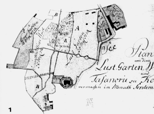
Fig. 1. The central part of Hahn's plan
Hahn's plan (Fig. 1) consists of three separate parts, which present: a vineyard, an ornamental garden and a pheasant house behind Lake Kórnicki, in the Zoo Forest. This plan is the most beautiful graphically - it is very colorful, the individual colors, carefully selected, correspond to various forms of land use and different buildings. For example, the hop garden in the farm part by the lake, in Prowent, is yellowish with red lines, the ornamental garden is pink, the vegetable gardens and kitchen gardens are green, and finally the eastern and southern borders of the ornamental garden (fence, wall or just an imaginary border?) are marked with red. line.
However, we can locate the vineyard - the plan of which is completely devoid of any elements of its immediate surroundings - thanks to the fact that there is an octagonal building marked there, also visible on many later plans. The vineyard was established on the edge of the plateau, in the area of the modern buildings of the institute, on plots 32, 33 and 36. To the east of the ornamental garden, you can see a two-row poplar alley, planted a few years before the plan was drawn up, enclosed by a building on the west (Bojarczuk 1970a, Bojarczuk 1970b). For half of its length, in the part closer to the castle, the poplar alley runs along the causeway. In addition, there are two octagonal pavilions in the garden - one of them will later house part of the library collections, currently there is a dendrological museum (Dolatowski 1994), two greenhouses, and at the southern border of the garden four small buildings, perhaps two gates? The road to Bnin runs differently than today, through the middle of Provent, and the local "Kuchen-Garten" (today a large parking lot) directly meets the "Lust-Garten"..
Ziehlke's plan shows us many details of the ornamental garden that Hahn's plan completely misses. Let's start with the "outskirts" of the park. The vineyard and the slope adjacent to it from the north-west were taken over by a large orchard, the octagonal building still exists (Fig. 2). There is a windmill right next to it, today it is more or less the northern gable of the institute's main building. A little west of the windmill, there was a building demolished in the early 1960s that housed the funeral home of the Jewish cemetery on the slope. At the foot of the plateau, north of the orchard, there is a ditch running diagonally, which will be hidden under the ground only after World War II. In Prowent, an unchanged, cobblestone (? or only up to the height of the park greenhouses, and then a dirt road towards Bnin?) runs between the distillery, the brewery and the forge (the last building still exists today) and is separated by a barrier ("barrire") at the height of the greenhouses. . We see an identical barrier at the entrance to Podzamcze. To the south of the greenhouse there is a part of the park purchased by Tytus Działyński, two of the three windmills remain, and the extension of the road running on the axis of the castle has already been planted with trees. The central part of the ornamental garden is shown in Fig. 3. This is the state before the reconstruction of the geometric garden into an English park. The road on the castle axis is surrounded by single or double rows of linden trees, symmetrically arranged quarters on both sides of the park axis are filled with rows of linden trees and hornbeam trees (the remains of hornbeam lines running from east to west can still be seen today in section 13).
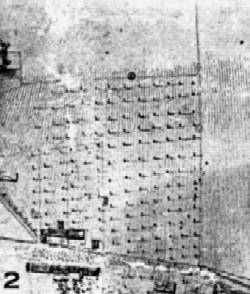
Fig. 2. Ziehlke's plan, fruit orchard
On the axis of the garden, slightly south of the two pavilions, there is a large coniferous tree growing in a circle - it is a Caucasian fir, called "Queen Jadwiga", cut down only in 1943. It is worth taking a look at the area around the greenhouse. On their northern side, surrounded by a well with a crane (the second such well supplied water in the manor courtyard, behind the eastern castle annex, and the third can be seen at the intersection of modern Średzka and Parkowa streets, near the "guest" in Piaski, which in the times of the foundation of the Kórnik Gardens (housed offices on the ground floor, and Antoni Wróblewski's apartment on the first floor) citrus trees, myrtles and pomegranates in buckets were put out for the summer (and Ziehlke showed this!).
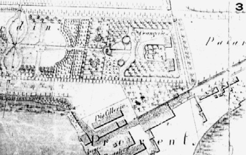
Fig. 3. Ziehlke's plan, ornamental garden
From the south you can see a long and narrow depression, closed from the east by a small building (one of the four buildings from Hahn's plan?), today called the "shooting gallery" and probably incorrectly deciphered as a remnant of sunken greenhouses - meanwhile this ditch, currently closing section 19 from the north, exists on the plan independently of the greenhouses that were later liquidated by Tytus Działyński. The two-row poplar alley, immortalized by Hahn, intersects on Ziehlke's plan with a new one, also two-row; this is the current road junction at the junction of sections 5, 6, 7 and 8 (Figure 4).
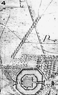
Fig. 4. Ziehlke's plan, poplar avenues
Both Biderman's plans introduce us to a completely different, "degeometrized" park, in which only the main road on the castle axis and crossed poplar alleys remain from the old elements, and on the "small" plan there is also the eastern of two triangular "wings" of a regular garden, which it was located in the immediate vicinity of the castle (Fig. 5). The two plans, although dating from the same year, differ in other details - for example, in the "small" plan, an extension of the main park road, lined with oaks, runs far between today's sections 19 and 22, while Biderman's "large" plan takes us back in this even "before" Ziehlke's plan, cutting off the alley at the level of the ditch - the "shooting range", and in the further perspective it shows not an alley, but clumps of trees. Perhaps the extended avenue was neglected, as - as it is today - only a park road, in a rather "uncivilized" environment, with no communication connection with the road running south over the lake?
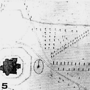
FIg. 5. Biderman's plan, castle surroundings
This route leading over the lake towards Bnin runs diagonally in Podzamcze, just like today, it "broke away" from the eastern annexes, and in Prowent it moved east, abandoning the courtyard next to the forge, so it is also "contemporary". In the area of the former vineyard, an octagonal building from the times of Hahn's plan still dominates the slope. In the area of the eastern annexes of Podzamcze, the "handy" garden is divided into a number of sections, from the east it is bordered by a pond, which we can see today in an identical form in section 2. The greenhouses in the park were removed, and the orangery was added to the southern gable of the eastern annex of the castle. To the south of the former orangeries and the long ditch, you can now walk along an arched path that still crosses section 19. In front of the new orangery there is a small, heptagonal garden, protected from the west by a wall with a gate, the same brick wall with a gate still stands nearby to the north from "Klaudynówka".
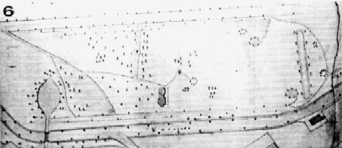
Fig 6. Biderman's plan, surroundings of the park pavilion
The area of still alien land in the area of today's sections 2 and 3 is presented slightly differently on both plans - on the "large" one there is a pond, an oval pond, in a notch of land purchased from neighbors, in the very north-eastern end of the arboretum, more or less there, where is the "eye" in the alpinarium today? The biggest changes were in the oldest part of the park - one of the ponds was filled in, one of the pavilions was demolished, and an annex was added to the preserved one for library collections. The path layout has also changed to a very modern one. Near the pavilion, the paths were laid so that, while walking, one could reach the "porches" - with the large spruce in the center of today's section 13, called "Kazimierz Wielki" and the already mentioned Caucasian fir (Fig. 6). Throughout the park there are many circular or elliptical gazebos made of trees and shrubs, some of which have paths leading to them. In the next plans, the number of these gazebos will systematically decrease. A little south of the intersection of poplar avenues, near three "tree" gazebos, an octagonal pavilion was built, the traces of which cannot be found today in section 8 (Fig. 7).
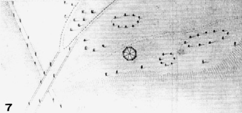
Fig. 7. Biderman's plan, trees planted in ovals
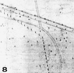
Fig. 8. Biderman's plan, eastern part of the park
The road accompanying the poplar alley splits like a snake's tongue on the border of sections 6 and 8, to the left it runs towards foreign lands and gardens at today's Parkowa Street, to the right the road begins a large gap, almost unchanged to this day, surrounding the park. In the eastern part of the park, where the dirt road began, leading to the village of Kromolice (today it is Modrzewiowa Street), this arch, on the "small" Biderman plan not yet shaded by trees, and on the "large" plan - shaded (?), is accompanied by a ditch bending at an obtuse angle, regularly planted with trees; these trees, in turn, are very few on the "large" plan (Fig. 8). The trees along the arch in the "large" plan are not yet lindens, having been planted there very densely twenty or more years after Biderman drew up the plans. When looking at Ziehlke and Biderman's plans, it is impossible not to smile - the shadows, painstakingly painted next to each tree, are cast by the sun, which must have traveled on the northern side of the sky!
Kausz's plan, developed 17 years later, introduces few spatial changes; It is impossible to say anything about changes in trees and shrubs, as no plants were noted on the plan. A lot of land was incorporated into the arboretum in its north-eastern part, and in this part the park resembles modern times in shape, although it still fully retains the internal paths of the old, incorporated farmyards (Fig. 9). The pond known from Biderman's "large" plan and the broken ditch, planted with trees, have disappeared, and the avenue on the castle axis now runs to the end of the park.
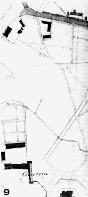
Fig. 9. Biderman's plan, northern part of the arboretum
On Pudrewicz's plan, the last of the 19th-century plans, there is no longer a pavilion of the former vineyard, and the mysterious octagonal pavilion from Biderman's plans has also disappeared, although there is still a path leading to it, in accordance with the iron rule of persistence - trees are falling, buildings are falling apart, but the roads to them are guides usually have a much longer lifespan. In the north-eastern corner of the arboretum there is no trace of the old roads from the purchased tracts of land. There is a path running along the southern side of the "shooting range" ditch, and a road runs along the southeastern edge of the area, all the way to the main ditch, which runs in the middle of the park, almost like the border of sections 21 and 23 today.
Stecki and Kulesza's plan, as it was published, I will not discuss in more detail. This is the first plan of the arboretum where the trees have been inventoried. In Podzamcze, there are now kitchens on the foundations of the greenhouses that Tytus Działyński moved here, and the greenhouses, no longer for collection purposes, but for economic purposes, have retreated even further north, to the farm yard, where their remains, decaying and slowly being dismantled, still stand on section 1. There is no transverse road leading through the middle of the park to the border of sections 8 and 11, you can reach the library pavilion in a slightly different way than today, via one of two paths - "porches", leading to the tulip tree (destroyed by lightning, it now grows in the depths of the western part of section 13) and to the previously mentioned large Norway spruce in the eastern part of this section. The fragment at the southern part of the castle moat looks different from what it will be like in a few years, when Wróblewski will start transforming the arboretum.
The cadastral plan does not contain information that is interesting to me, it only provides the area of individual forms of land use in the arboretum; There were 4.34 ha of "gardens" and over 15 ha of "forests" (!).
The plan of the nurseries, the western part of which is shown in Fig. 10, I show it to remind you that the northern part of today's new part of the arboretum, its section 24 and the gardens on the northern side of the director's house at ul. Parkowa 3 is a fragment of the cemetery (Dolatowski 1993). The tombstones destroyed during World War II can only cast diagonal shadows on the ground in this plane.
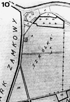
Fig. 10. Plan from before World War II, nurseries and a Jewish cemetery
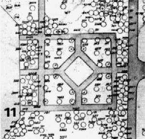
Fig. 11. Wróblewski's plan, geometric layout from the southern side of the castle
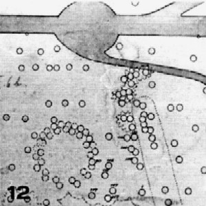
Fig. 12. Wróblewski's plan, a circle of trees
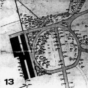
Fig. 13. Plan Wróblewskiego, szklarnie
Wróblewski's plan is a memento of his illness and death in 1944. This very large plan (unfortunately, heavily damaged due to years of improper storage), which must have taken a lot of work and time, remained unfinished; Wróblewski probably drew it mainly in 1943, but in the spring of the following year he probably felt too bad. All trees and shrubs were supposed to have arboretum inventory numbers, but only some of them were included in the plan by the author. The plan resembles today's image of an arboretum, a transverse alley runs through the middle, dividing the areas of sections 8 and 11, the access to the pavilion, which currently houses the dendrological museum, is the same as today - the border of sections 13 and 14.
The paths around Wróblewski's office and apartment in the former guesthouse in Piaski, i.e. next to the "hospital" are arranged in a slightly different, decorative way - this building was then directly connected to the park, to which two paths carefully planted with perennials led, very similarly to how Wróblewski arranged it in his "first" arboretum in Fredrow near Lviv. One of these paths still divides sections 3 and 6. In front of the castle, on its northern side, there were several lawns with gentle shapes, and on the side of the former greenhouses, and later kitchens, there is still a wall, which ends in emptiness on the eastern side - the kitchen does not exist.
On the southern side of the castle, Wróblewski created - referring to the old geometric gardens that were located here - symmetrically drawn flower beds (fig. 11). Currently, the path layout is different here, but you can still see the symmetry of groups of identical bushes "reflected" in the line of the main avenue. In the area of the "shooting range" there was the last tree arbor; next to one of the plants (was the circle single-species?) there is the number "90", which according to the inventory books means Virginia juniper (Fig. 12). The area south of the greenhouse, i.e. its section 1, now separated from the arboretum, also looked different than today (Fig. 13). To remind you of the past glory of the arboretum, here are the vines that grew in Wróblewski's times near the northern wall of the low greenhouse, which would be impossible to find in Kórnik today: Jasminum stephanense (received in 1936 from Stefan Makowiecki), Schizophragma hydrangeoides, Rubus playfairianus and Decumaria barbara.
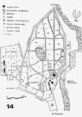
Fig. 14. The Kórnik Arboretum today
Jakub Dolatowski
Szkoła Główna Gospodarstwa Wiejskiego,
Wydział Ogrodniczy - Oddział Architektury Krajobrazu,
Samodzielny Zakład Dendrologii,
ul. Nowoursynowska 166, 02 787 Warszawa
SUMMARY
In the article changes in the park architecture of the Kórnik-Arboretum were shortly described basing on 11 old plans stored in the library of the Institute of Dendrology and the library of the Castle of Kórnik. These plans concern the period from 1780 to 1943. It appears that plant compositions undergo changes easily, for example only few great alleys survive from the Tytus Działyński's days. In contrast with the trees arrangements the lay-out of the main axes and paths still exist.
BIBLIOGRAPHY
- Białobok S., 1955. Rys historyczny Zakładu Dendrologii i Pomologii w Kórniku oraz ogólna charakterystyka kolekcji drzew i krzewów. Arbor. Kórnickie l: 7-30.
- Białobok S., 1960. Historia introdukcji i aklimatyzacji drzew i krzewów w Arboretum Kórnickim. Arbor. Kórnickie 5: 141-198.
- Bojarczuk T., 1970a. Sędziwe topole czarne (Populus nigra L.) w Arboretum Kórnickim. Rocz. Sekcji Dendr. PTB 24: 87-90.
- Bojarczuk T., 1970b. Wiek niektórych drzew w Arboretum Kórnickim. Arbor. Kórnickie 15: 29-45.
- Bugała W., Bojarczuk T., Dolatowski J., 1990. Arboretum Kórnickie - Przewodnik. PWN, Warszawa - Poznań.
- Celichowski Z., 1906. Ogród zamkowy w Kórniku. Bibl. Kórnicka, Poznań.
- Dolatowski J., 1993. Cmentarz żydowski w Kórniku. Ziemia Kórnicka 10: 11.
- Dolatowski J., 1994. Muzeum Instytutu Dendrologii PAN w Kórniku. Kronika Wielkopolski 4(67): 115-118.
- Stecki K., Kulesza W., 1926. Opis parku w Kórniku. Roczn. Pol. Tow. Dendr. l: 70-104.
The text was published in the "Bulletin of Botanical Gardens" in 1997 (6:75-84)
